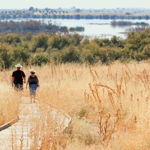
Twenty scenic walks take you past some of the best sights these cities have to offer—and they give you a workout to boot.
Take a Walk
More than just get you from Point A to Point B, a good walk can provide exercise, exposure to fresh air and nature, and—bonus—even up-close-and-personal views of landmarks, if you plot your route well. To find 20 rewarding walks that fit that criteria, we talked to experts who live in, commute around, and regularly travel (on foot!) the top 10 walking cities for 2014, as ranked by Walk Score (a website that analyzes walkability based on available routes and amenities like entertainment, shopping, and parks). The routes suggested by our pros—walking coaches and advocates, tour guides and city officials, and authors who write about (what else?) walking—are all at least three miles, to get you well on your way to the 10,000 steps a day recommended by health researchers. Aim for a consistent moderate pace, and if possible wear lightweight walking sneakers and a pedometer to help you track your distance. And don’t forget your smartphone: You can access 10 of our routes via Google Maps (create shareable maps for desktop or phone of your own favorite walks at Google Maps Engine Lite) as well as exclusive Spotify playlists customized to each city—and guaranteed to get you moving.
New York City
The Big Apple earns Most Walkable City distinction, thanks to its high density of cultural institutions, restaurants, parks, and public transportation services (for the return trip, if you don’t care to hoof it), especially in the boroughs of Manhattan and Brooklyn. In fact, many New Yorkers go their entire lives without ever owning a car.
Best Walk: Central Park
You can’t beat the smooth, rolling hills and lush greenery of Central Park, says Lon Wilson, president of the New York Walkers Cluband a national racewalking champion. (In fact, his club holds walking clinics in the park every Saturday at 9:30 a.m.) For a nice 4.1-mile jaunt around the park’s famous Jacqueline Kennedy Onassis Reservoir, enter at East 90th Street and 5th Avenue and turn right, heading north, onto East Drive. Turn left at the transverse at roughly 106th Street, then left again (heading south) onto West Drive. Make another left at the 72nd Street Transverse (also known as Terrace Drive), and one more (heading north again) onto East Drive, back to 90th Street. To access the map, click here.
Alternate Walk: Lower Manhattan and Brooklyn Bridge
For a more urban stroll, start at the 9/11 Memorial on Liberty Street in downtown Manhattan. Walk west to the Hudson River, where you’ll turn left onto the waterfront esplanade. Follow this tranquil walkway around the bottom tip of the island, through South Cove Park and Battery Park and past the Staten Island Ferry and the historic Battery Maritime Building. Continue northeast along what is now the East River Waterfront Esplanade. Just past the South Street Seaport, pass under the FDR Drive and make a left onto Beekman Street, a right onto Pearl Street, a left onto Frankfort Street, and a sharp right onto Park Row, which will take you to the pedestrian entrance (via a tunnel and staircase) for the Brooklyn Bridge. After your 1.5-mile trek across the bridge (four miles for your total trip), take the subway or ride a Citibike back to Manhattan.
San Francisco
California’s City by the Bay has plenty of rewarding views for willing pedestrians. Its 42 hills and more than 600 stairways add an extra challenge, says Aaron Dence, a personal trainer and walk leader for the nonprofit organization Walk SF, but locals and tourists alike learn to love them for the built-in workouts and breathtaking vistas they provide. “Give yourself more time than you think you need for these walks,” says Dence, “since you’ll want to take your time on your way up.”
Best Walk: Chinatown, North Beach, Telegraph Hill, and Jackson Square
Begin this three-mile walk at San Francisco’s iconic Transamerica Pyramid Center, at the intersection of Merchant and Montgomery streets. Walk south on Montgomery and then right onto Clay Street. At the end of Portsmouth Square Plaza, turn right onto Walter U. Lum Place. Walk to the end of the plaza, then turn left on Washington Street. Make a right onto Ross Alley (grab a sample at the Golden Gate Fortune Cookie Factory!), a right onto Jackson Street, and a left onto Grant Avenue. Turn right on Jack Kerouac Alley to pass the famous beat poet hangout City Lights Booksellers, then turn left on Columbus Avenue. At Broadway Street, make a left and walk about 250 feet, then turn around and look up to catch a glimpse of the “Language of the Birds” sculpture, a collection of books seemingly frozen in thin air. Walk back to Columbus Avenue, making a left. Bear right at Stockton Street and walk along—or stroll through—Washington Square Park. At its northern border, turn right on Filbert Street. Follow Filbert Street as it twists and turns and becomes the Filbert Steps, and wander down the intersecting alleys to see picturesque San Francisco homes and gardens. In Levi’s Plaza, bear left at the circle and head north. Make a right onto Battery Street, then a quick left onto Greenwich Street. Follow the road (and stairs) to Telegraph Hill Boulevard, where you can check out a statue of Christopher Columbus overlooking the city. Turn back and head southeast on Telegraph Hill Boulevard to explore Coit Tower and its surrounding grounds. Return to Greenwich Street and turn left (west) out of the park. Turn left on Grant Avenue, then left on Vallejo Street. After the Vallejo Street stairs, turn right on Montgomery Street. Make a left on Gold Street, a right on Balance Street, a right on Jackson Street, and a left on Hotaling Street. Finally, make a left on Washington Street and a right into Transamerica Redwood Park, where your tour comes to an end. To access the map, click here.
Alternate Walk: Nob Hill and Russian Hill
This walk starts outside of Grace Cathedral, at the corner of Sacramento and Taylor streets. Head east on Sacramento Street and turn left on Mason Street, where you’ll pass the San Francisco Cable Car Museum. Turn left on Vallejo Street and follow it up one set of stairs, through Ina Coolbrith Park, and then up another set. Turn right on Jones Street, right on Green Street, left on Taylor Street, and left on Macondray Lane. Continue zigzagging through Russian Hill, turning right on Leavenworth Street, left on Greenwich Street, right on Larkin Street, left on Chestnut Street, and right on Polk Street. From here, turn right on Francisco Street, which curves north into Russian Hill Park. At the end of the park, turn right on Hyde Street and left back onto Francisco Street. Turn right on Leavenworth Street to head south, then make a right on Lombard Street to travel down the city’s “crookedest street,” consisting of eight hairpin turns and flanked by beautiful homes and gardens. To finish the 3.3-mile tour, turn left on Hyde Street, left on Filbert Street, right on Jones Street, left on Vallejo Street, right on Florence Street, left on Broadway Street, and right on Taylor Street to return to Grace Cathedral.
Boston
It’s no wonder Beantown made the list: One of its nicknames, after all, is the Walking City. It’s home to America’s oldest public park, a riverfront pedestrian-and-bike path, and the Freedom Trail, a brick-lined route through the city that leads to 16 historical sites.
Best Walk: Charles River Esplanade
Whether you’re running, walking, or biking, the century-old Charles River Esplanade is an athlete’s dream, says Brendan Kearney, development and communications manager for the nonprofit organization WalkBoston. To experience the best parts of the waterfront walkway, begin your stroll on the west end of the Longfellow Bridge, at First Street and Broad Canal Walk. Climb the stairs and cross the bridge. When the sidewalk ends, turn right to cross under the bridge, then turn right again onto the Charles River Esplanade. Follow the esplanade west to the river and around a loop, then head south with the water to your right. Travel south around the Hatch Memorial Shell and across a small island. Take the ramp to Massachusetts Avenue, and turn right to cross the Harvard Bridge back over the river. Once across the bridge, turn right onto the Memorial Drive waterfront pedestrian path and follow this northeast, back to and under the Longfellow Bridge, to finish your 3.2-mile loop. To access the map, click here.
Alternate Walk: The Freedom Trail
If you’re more interested in Boston’s rich colonial history, follow the red-brick Freedom Trail through the city. For a 3.5-mile walk, start at the USS Constitution Museum in the Charlestown Navy Yard. Head north to Baxter Road and turn left on First Avenue, then right onto the Freedom Trail. Follow the trail past Winthrop Square to Bunker Hill Monument Park, with its memorial to Revolutionary War soldiers who died in the famous battle. Back at Winthrop Square, head southwest on Winthrop Street and turn left on Warren Street, then right on Park Street. After meandering through the City Square, turn left on Washington Street and head over the Charles River on the Charleston Bridge. At the foot of the bridge, turn left on Commercial Street, then right on Hull Street. Pass by the Old North Church and through the Paul Revere Mall, then turn right on Hanover Street. Make a left on Prince Street, a right on Garden Court Street, a right on Richmond Street, and a left back onto Hanover Street. Turn right on Cross Street, then turn left at Salem Street into North End Park. Head southwest through the park and turn right, back onto Hanover Street, then bear left onto Marshall Street. Turn left on Union Street and travel south along Union Street Park. After the park, follow the Freedom Trail left and then right, past Merchants Row, then right again to Congress Street. Turn left on Congress Street, right on State Street, and left on Washington Street to the Irish Famine Memorial. Turn right on School Street and left on Tremont Street, then turn right into Boston Common, the nation’s oldest public park. After exploring the park, end your walk at the Visitors Center at 139 Tremont Street.
Philadelphia
There’s a lot for a walker to like about the City of Brotherly Love: a large system of parks and riverfront trails, historic Center City and Penn’s Landing, a bustling university population, and eclectic neighborhoods full of boutiques, coffee shops, and restaurants.
Best Walk: Boathouse Row and Fairmount Park
A brisk 3.5-mile stroll along the Schuylkill River will highlight many of Philadelphia’s charms, says Meryl Levitz, president and CEO of Visit Philadelphia. Begin your walk at 25th and Locust streets, and head west toward the Schuylkill River. Turn right onto the Schuylkill River Trail, which runs 26 miles from Philadelphia all the way to Valley Forge. About a mile down the trail, you’ll get a good view of the Philadelphia Museum of Art (home to the famed Rocky Steps). Pass the museum on your right and then the city’s historic waterworks, and continue along the path through Fairmount Park. Next you’ll pass Boathouse Row, a collection of 19th-century boat sheds and social clubs on the river; about a mile later, you’ll come across the whimsical Playing Angels statues. From here, cut to your right across the grass to Fountain Green Drive. Take the path along Fountain Green Drive and turn right down the path toward Smith Playground. Cross Smith Day Nursery Drive and continue east along Reservoir Drive out of Fairmount Park. At the edge of the park (33rd and Oxford streets), catch the No. 32 city bus to Center City. To access the map, click here.
Alternate Walk: Center City, River to River
This 3.9-mile walk through history begins outside the Liberty Bell and Independence Hall. Start at Sixth Street and Chestnut Avenue, walking east on Chestnut. Turn left on Fifth Street and right on Arch Street. (Toss a penny onto Ben Franklin’s grave!) Turn right on Second Street and walk south toward Market Street. Turn left to walk across the Penn’s Landing Bridge, noting the historic ships and the Great Plaza below. Continue on the bridge until it meets back up with Chestnut Street, and take a right. Make a left on Third Street and then a right on Spruce Street. Walk half a mile and turn right on Broad Street, where you’ll see City Hall a few blocks north. Turn left on Locust Street at the Academy of Music, and walk until you reach Rittenhouse Square. Turn right and walk along 18th Street to the Benjamin Franklin Parkway. Turn left on the parkway, cut through Logan Square, and pass Sister Cities Park on your right. Continue on the parkway to 20th Street, and turn right into the Barnes Foundation, open late on Friday nights for live music.
Miami
Whether you like walking on sand or sidewalk, sunny Miami’s got a path (make that lots of paths) for you. Miles of beachfront boardwalk and promenade flank the city and its satellite island, Miami Beach—and if that’s not enough for you, the mayor frequently closes major roadways to cars, giving free rein to pedestrians and bikers.
Best Walk: Rickenbacker Causeway
It’s hard to find a better route—for a good workout or just a scenic walk—than Rickenbacker Causeway, says Joe Scott, a Miami-based walking coach with the Leukemia and Lymphoma Society’s Team in Training program. “On any given Saturday, you’ll be joined by literally thousands of other walkers,” he says. Begin at Peacock Park in Miami’s Coconut Grove neighborhood, located at McFarlane Road and South Bayshore Drive. Head north on South Bayshore Drive for two miles, cross U.S. Route 1, then turn right on SW 26th Road. Make your way to the walking path along the Rickenbacker Causeway. Continue on the causeway another mile, to its highest point— a great spot to scope out the gorgeous scenery before heading back to the mainland. Turn around and head back to the mainland, to end your 4.3-mile walk in Alice Wainwright Park. To access the map, click here.
Alternate Walk: South Beach
Miami Beach’s bustling South Beach section is best known for its nightlife, but it’s also the perfect place for a morning or afternoon stroll, says Scott. Pedestrian-friendly walkways stretch for miles, just feet from the water—or, if you’re up for a bit more of a challenge, you can head out onto the sand itself. For a pleasant 3.3-mile jaunt, start at South Pointe Park Pier at the southernmost tip of Miami Beach and follow the waterfront walkway (or the beach itself) north. After about a mile, you’ll pass through the 74-acre Lummus Park, which runs from 5th to 15th Street. End your walk at 36th Street Park; you can find public transportation one block west at Collins Avenue.
Chicago
Acres and acres of parkland and the banks of Lake Michigan make the Second City a shoo-in for one of America’s most walkable locales. “Chicago is a good walking city simply because it’s flat: You can walk for miles with hardly any effort,” says Ryan Van Berkmoes, author of Walking Chicago ($20, amazon.com). “But it’s the architecture, neighborhood flavors, beauty, and endless surprises and discoveries that make it a great walking city.”
Best Walk: Washington Park and Jackson Park
This four-mile stroll is particularly lovely on a sunny day, says Van Berkmoes. Start in the northwest corner of Washington Park, at 51st Street and Martin Luther King Drive. Head south on the park’s tree-lined path to 55th Street, then turn left to cross over Ellsworth Drive and head east along the main road. Cross Rainey Drive and walk south along Morgan Drive to the DuSable Museum of African American History. From here, follow the curving path south through the park, joining up with Payne Drive just before the Fountain of Time sculpture. Walk east from the fountain into grassy Midway Plaisance, which stretches almost a mile. Cross under the railroad tracks near 59th Street and continue east to enter Jackson Park. Cross South Stony Island and South Cornell Avenue; about 350 feet later you’ll come to a fork in the road. (You should see the lagoon ahead and to your right.) Follow the path to the right over the bridge to Wooded Island, where you’ll pass the Japanese Osaka Garden. Keep an eye out for birds and wildlife as you walk south to cross the bridge at the far end of the island, continuing onto East Hayes Drive. Turn left and continue over a small bridge, then veer north on a narrow trail that curves back up along the lagoon and past the park’s driving range. Finish your walk by continuing north over another bridge to the parking lot at Columbia Drive or exiting the park at 59th Street to catch a city bus. To access the map, click here.
Alternate Walk: Grant Park to Northerly Island
Start this 4.1-mile walk at the southeast corner of Monroe Street and Columbus Drive. Cross diagonally through the wide-open spaces of Butler Field, then pick up the path just east of the bandshell and cross over East Jackson Drive. Walk up the steps to Buckingham Fountain and its reflecting pool. Turn right to walk west along East Congress Parkway and cross over the Metra train tracks, then turn left to follow the park south between Michigan Avenue and the train tracks. At East 9th Street, climb the hill to the monument of General John Logan. Turn right to follow the walkway south from the monument to a pedestrian bridge over the train tracks. Continue east on the bridge and follow the curve down and under Columbus Drive. Walk south to the statue of Christopher Columbus, then north over the grass to a wide walkway that leads to the Museum Campus, a 57-acre park that surrounds three of the city’s science museums. Take the Lake Shore Drive underpass to the Museum Campus, then cross the plaza and loop around the Shedd Aquarium. From here, head east to the Adler Planetarium, then turn right to take the narrow walkway down to the 12th Street Beach. You’ll find a path that runs south through the heart of Northerly Island. Follow this outer loop down the east side of the island and back up the west side, ending your walk on South Linn White Drive and East Solitary Way, where you can catch a bus back to your starting point.
Washington, D.C.
Between the National Mall and the pedestrian-friendly neighborhoods—not to mention all those famous monuments—the nation’s capital is a walker’s paradise, with plenty of paths that allow for brisk, heart-thumping strolls, says Vanessa Garrison, founder and director of GirlTrek, a nonprofit dedicated to inspiring African-American women and girls to walk and exercise more.
Best Walk: National Mall and Lincoln Memorial
Begin this 3.3-mile walk at Pennsylvania Avenue and Eighth Street, outside the Eastern Market Metro Station. Head northwest on Pennsylvania Avenue for about half a mile, then continue left onto Independence Avenue when it merges with Pennsylvania Avenue. At the intersection of Independence Avenue and First Street SE, bear right onto Southeast Drive, heading toward the U.S. Capitol Building. Follow as it becomes Southwest Drive, skirting the Capitol and heading toward the President James Garfield Memorial. Turn right (north) onto First Street SW, then travel counterclockwise three-quarters of the way around the traffic circle, exiting onto Maryland Avenue. Head west to Third Street SW, then turn right. After passing Jefferson Drive, turn left to enter the National Mall. Walk west to 14th Street SW, then turn left and walk to the crosswalk at Jefferson Drive to cross over 14th Street SW. Follow this path west, past the Washington Monument, the John Paul Jones Memorial, the World War II Memorial, and the Lincoln Memorial Reflecting Pool, and end your walk at the steps of the Lincoln Memorial. To access the map, click here.
Alternate Walk: Adams Morgan and Rock Creek Park
Explore the Adams Morgan neighborhood and the picturesque trails of Rock Creek Park on this 4.2-mile walk. Beginning at 18th Street and Columbia Road, head north on Adams Mill Road. Continue onto Calvert Street over Rock Creek on the Duke Ellington Memorial Bridge. Just past Shoreham Drive, turn left onto the Rock Creek Park Trail. Bear right at the fork, following the trail and crossing back over Rock Creek three more times over the next 3.5 miles. Follow the trail south, with the Potomac River on your right, until you pass the John Ericsson National Memorial. Cross over Ohio Drive and turn left (north), toward the Lincoln Memorial where you’ll end your walk.
Seattle
With such companies as Amazon, Microsoft, and Starbucks based there, Seattle has seen considerable economic growth in recent years—and it shows in the city’s infrastructure, which has become increasingly walker-friendly. “Seattle provides a great variety of terrain to walk,” says Barbara Reisinger, a Seattle-based racewalking coach for the Crohn’s and Colitis Foundation of America’s Team Challenge. “Walkers are able to get a distinct feel for each of the unique neighborhoods that make up Seattle while also enjoying some of its most famous landmarks.”
Best Walk: Waterfront Elliott Bay Trail
For a beautiful three-mile stroll along Puget Sound, begin at Pier 57, home to the Seattle Great Wheel. Head northwest along Alaskan Way, with the water to your left. After passing Waterfront Park and the Seattle Aquarium, enter the Olympic Sculpture Park, which provides a great view of the Space Needle to the northeast. Zigzag back to the waterfront path and continue north, with spectacular sightings of the Olympic Mountains, Mount Rainier, and Puget Sound, as you travel through Myrtle Edwards Park and then Centennial Park. End your hike (or turn around to double the distance) where the Elliott Bay Trail intersects with 16th Avenue, just before the Magnolia Bridge. To access the map, click here.
Alternate Walk: Gas Works Park and Fremont
This 3.2-mile walk showcases the fun and funky neighborhood of Fremont, while offering unique views of the city across the lake. Start at North Pacific and 35th streets, walking south to meet the Burke-Gilman Trail. Pass through Gas Works Park, exiting it to the west, staying on the Burke-Gilman Trail. Head west along the trail until it joins up with North 34th Street at Stone Way North. Follow North 34th Street west to its intersection with Fremont Avenue North. (Snap a photo here of the famous statue “Waiting for the Interurban.”) Cross Fremont Avenue North, with the drawbridge to your left, still heading west along North 34th Street, until you reach Phinney Avenue North. Turn right on Phinney Avenue, then right on North 36th Street. Cross under the Aurora Bridge, where you can climb on the beloved “Fremont Troll” sculpture. Continue along North 36th Street to Stone Way North, and turn right to head south toward the water. Follow the road as it curves left and becomes Northlake Way and then Northlake Place, into Gas Works Park, to its southern tip, and then north past the Gasworks slackline. Rejoin the Burke-Gilman trail and walk north, back to your starting point.
Oakland
The Bay Area’s “second city” is in the midst of a revitalization that includes miles and miles of pedestrian paths, says Tyler Norris, cochair of Kaiser Permanente’s Every Body Walk campaign. “Oakland has become a place to walk to work, for fitness, for social purpose, or just for running errands,” he says. He specifcally notes the city’s volunteer-driven Walk Oakland Bike Oaklandorganization, whose goal is to promote both of those activities and advocate for walking- and biking-friendly city planning.
Best Walk: Lake Merritt
Known as the jewel of Oakland, Lake Merritt houses the oldest wildlife refuge in North America, along with a nature center, an arboretum, and a children’s fairy-tail-themed playground. To explore the lake’s scenic, 3.3-mile inner loop, begin at its northwest corner, near Grand Avenue and Harrison Street. Walk east on Grand Avenue, and turn right on Bellevue Avenue to follow the curve of the lake. Continue along Bellevue Avenue as it wraps back up to Grand Avenue, and turn right to continue along the outer loop. At the northeast corner of the lake, turn right onto El Embarcadero, then make a right onto Lakeshore Avenue. This road will take you to the bottom of the lake, where you can cut into a waterfront path past the Lake Merritt United Methodist Church and over a small footbridge. After you pass the Lake Chalet Seafood Bar and Grill, join up with Lakeside Drive and follow this road back up to your starting point. To access the map, click here.
Alternate Walk: Piedmont Avenue and Adams Point
A 3.5-mile walk through some lovely tree-lined streets in North Oakland offers plenty of hills for those who want an extra challenge, says Norris. Start at Piedmont and Pleasant Valley avenues, near the foot of Mountain View Cemetery (another great walk in and of itself, according to Norris). Walk southeast on Pleasant Valley Avenue as it turns into Grand Avenue. Turn left on Cambridge Way, then make a slight right on Jerome Avenue, a left on Magnolia Avenue, and a right back onto Jerome Avenue. Turn right on El Cerrito Avenue, which winds up through Piedmont Park and around Witter Field. Turn right onto Wildwood Avenue and continue on this road as it curves northwest and eventually turns into Jean Street. Outside the Morcom Amphitheater of Roses, turn right up the old stairs and follow them to Olive Avenue. Turn left on Olive Avenue, keeping the rose garden to your left, then left on Oakland Avenue. Turn right on Bayo Vista Avenue, left on Fairmount Avenue, right on Yosemite Avenue, and right on Piedmont Avenue, which will lead you past lots of charming shops and restaurants (including local favorite Fenton’s Creamery) on your return to your starting point.
Baltimore
This former steel town, reborn as a technology and medical hub, is “a city with zero pretension and tons of character,” says Evan Balkan, author of Walking Baltimore ($19, amazon.com). “It’s northern and southern all in one. Take a stroll and you’ll see just how diverse we are: It’s like walking through 50 different cities just going from west to east.”
Best Walk: Downtown and Camden Yards
Start on the corner of North Charles Street and Lexington Street. Walk east on Lexington Street and turn right on Saint Paul Street, looking toward the harbor. Turn left on Baltimore Street and left on North Calvert Street, and walk around the Battle Monument. At the end of the block, turn right on Lexington Street. Past City Hall, turn left on North Holliday Street. Take a right on Saratoga Street, right on North Gay Street, right on East Fayette Street, and left back onto North Holliday Street. Turn left on East Baltimore Street, and take note of the gas lamp—a replica of the first gas lamp lit in the United States. You are now facing Baltimore’s famous racy Block, a collection of strip clubs that’s been around for almost 100 years. Turn right on South Gay Street, right on East Lombard Street, right on South Street, and left on East Redwood Street. Take a right on South Charles Street, a left on West Fayette Street, and a right on North Eutaw Street. Pass Lexington Market on your left (no need to stop just yet; you’ll be back later!), then turn left on West Saratoga Street. Turn left on North Paca Street and right on West Fayette Street, past the burial place of Edgar Allen Poe. Turn left on Greene Street, cross Washington Boulevard, and circle the Baltimore Orioles’ famous stadium, Camden Yards. Once around the stadium, walk toward Camden Station on West Camden Street, where you’ll find the Sports Legends Museum. To finish up this 3.8-mile tour, walk north on Eutaw Street back to Lexington Market for a hard-earned and delicious meal. To access the map, click here.
Alternate Walk: Harbor East and Fell’s Point
Begin on the corner of South Caroline and Lancaster streets, heading south toward the water. When Caroline Street dead-ends, make a left onto Thames Street, named for London’s river. Turn left on Bond Street and right on Shakespeare Street, a quintessential lane of tightly packed brick Baltimore row homes. Make a right on South Broadway and left back onto Thames Street, heading east and taking in the colonial character. Bear right on Fell Street and walk to the water, taking a moment to enjoy the view before turning around and heading north on South Wolfe Street. Turn left on Lancaster Street, right on South Ann Street, left on Aliceanna Street, and right on South Broadway. At Gough Street make a left and then another quick left back onto South Broadway going south. Make a right on Fleet Street and a left on South Caroline Street. At your starting location, make a right on Lancaster Street, heading west along the water. Follow the curve up and around the National Katyn Memorial, and continue northwest onto South President Street. After the Civil War Museum, make a left on Fleet Street and a quick right back onto South President Street, and follow this road north. Turn left on East Pratt Street, then right on East Falls Avenue along the water. Make a left at East Lombard Street to cross the river, then make your first right onto Jones Falls Trail. Turn left just past the Port Discovery Children’s Museum, then left again to head south to Market Place. Your three-mile walk ends in Baltimore’s bustling Inner Harbor, with plenty of restaurants, shops, and music venues nearby.
Source: Real Simple
January 15, 2014
By Amanda MacMillan, photo by Kate Powers
http://www.realsimple.com/health/fitness-exercise/workouts/most-walkable-cities-00100000116156/index.html